Last updated 23.10.2026
Most people picture Croatia as sea, islands and grilled fish on the beach. Yet right behind the narrow coastal strip a wild wall of rock rises up, and that is where the highest mountains in Croatia stand — the limestone giants of the Dinaric Alps, from which you look down on the Adriatic as if from a balcony. A sea view from a summit where the morning air is close to freezing is something you take home just as gladly as a tan.
This guide gives you an accurate, verified list of Croatia’s highest peaks with elevations and ranges, and shows you which of them actually see the sea. We add hikes an ordinary walker can manage (yes, the Biokovo Skywalk too), advice on when and how to go, and answers to the most common questions at the end. The point is that you can plan the trip yourself — and know what you are getting into.
The highest mountains in Croatia at a glance
- Highest mountain: Dinara (summit Sinjal) — 1,831 m, on the border with Bosnia and Herzegovina.
- Best sea view: Biokovo (Sveti Jure, 1,762 m) above Makarska — the cliff drops straight into the Adriatic.
- Range: they belong to the Dinaric Alps; Risnjak, Paklenica and Northern Velebit national parks protect them.
- A hike for anyone: Biokovo Skywalk (a glass platform at 1,228 m), park entry €10–15.
- When to go: ideally May–June and September–October; in summer the bare summits are hot and bone dry.
- Watch out: karst means almost no water and no shade — always sort out water and solid boots.
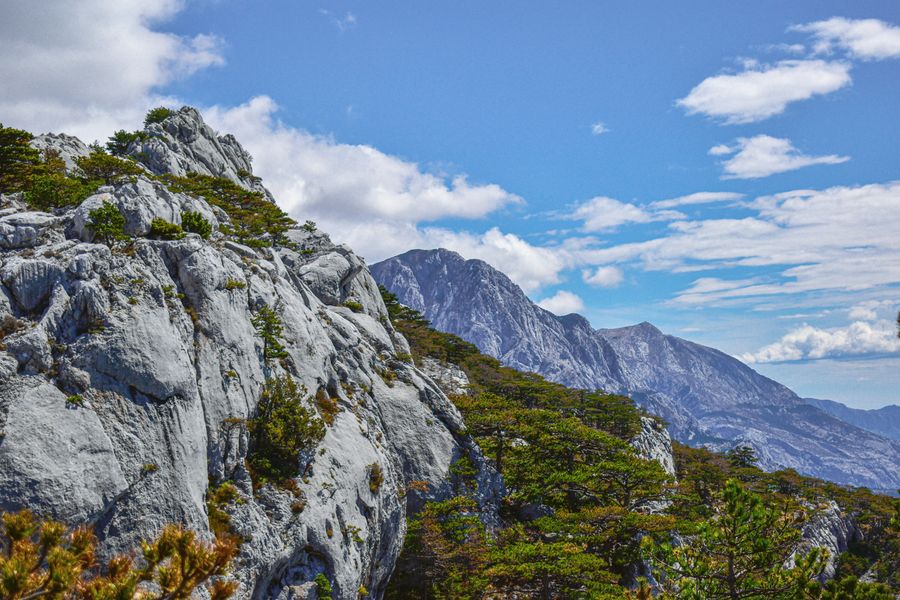
Croatian mountains and national parks (the Dinaric Alps)
Almost every high Croatian mountain belongs to the Dinaric Alps — a massive karst belt running along the coast from Istria to Dalmatia and on into Bosnia and Montenegro. This is limestone karst, and it will make you work: sharp rock, sinkholes, caves, hardly any streams and, in summer, fierce sun with no shade. The reward is enormous, though — from many ridges the sea lies right there below you.
Geographically the Croatian mountains fall into three big blocks. In the north, around Rijeka, lies Gorski kotar with the forested Risnjak National Park. Through the middle runs Velebit, the longest range in the country (protected by the Northern Velebit and Paklenica national parks). And in the south, above the Makarska Riviera, rises dramatic Biokovo, a designated nature park. The single highest summit, Dinara, sits further inland on the Bosnian border.
Worth knowing in advance: these are not the Alps with cable cars and a hut around every corner. Infrastructure is sparse, waymarking is sometimes minimal, and water is your own problem. In exchange you get quiet, wilderness and the feeling of being at the end of the world — a few kilometres from a beach full of people.
The 12 highest mountains in Croatia
We ordered them by the elevation of the highest summit in each range. For every mountain you get the elevation, the range or national park, whether you can see the sea, and how accessible it is. Elevations were cross-checked across sources (Croatian Wikipedia, the Croatian Mountaineering Association, dinarskogorje.com) — we give the most consistently confirmed figures, and where sources disagree we say so.
1. Dinara (Sinjal) — 1,831 m
Range: Dinara (Dinara NP) · Sea view: no, it sits inland · Access: moderately demanding full-day hike.
Croatia’s highest mountain shares its name with the whole range, and its summit is called Sinjal. It rises to 1,831 metres right on the border with Bosnia and Herzegovina, above the town of Sinj. Beware a common mix-up: the highest point of the entire Dinara massif is Veliki Troglav (1,913 m), but that one lies on the Bosnian side, so Croatia’s high point remains Sinjal. Since 2021 the area has been protected as the country’s newest national park. You will not see the sea from here, but you get a karst plateau below you and a view across the border into Bosnia. The usual ascent starts in the hamlet of Glavaš (around 560 m) on a marked trail, roughly 8 km one way; allow 3 to 4 hours to the top. About halfway up stands the basic Martinova košara shelter (around 1,300 m), useful if the weather turns.
2. Sveti Jure (Biokovo) — 1,762 m
Range: Biokovo (nature park) · Sea view: yes, the best in the country · Access: by car almost to the summit.
Sveti Jure is 1,762 metres and it is our pick for anyone who wants mountains and sea in one go. Biokovo rises straight out of the Makarska Riviera — from the top you look across the Adriatic to the islands of Brač and Hvar, and on a clear day as far as the Italian coast. Big advantage: a toll mountain road climbs Biokovo, so you can drive almost all the way up. That makes Sveti Jure the second-highest mountain in Croatia you can reach without serious fitness.
3. Vaganski vrh (Velebit) — 1,757 m
Range: Velebit (Paklenica NP) · Sea view: yes, across the Adriatic to the islands · Access: a more demanding mountain day.
The high point of Croatia’s longest range. Vaganski vrh reaches 1,757 metres and lies in southern Velebit above Paklenica National Park. Right next to it stands its slightly lower neighbour Sveto Brdo (1,753 m). In good weather the ridge gives you the sea and the islands of Pag and Rab. The climb is long and hard — count on a full mountain day and plenty of water, because in karst terrain there are effectively no springs.
4. Ozeblin (Plješevica) — 1,657 m
Range: Lička Plješevica · Sea view: no, inland (Lika) · Access: rarely visited, genuinely wild.
Plješevica is a long border ridge between Croatia and Bosnia in the Lika region. Its highest summit, Ozeblin (1,657 m), is among the least visited high mountains in the country — you are more likely to find bear tracks than people. Ideal if you want solitude and wilderness, but be ready for thin waymarking and no facilities at all.
5. Bjelolasica (Kula) — 1,533 m
Range: Velika Kapela · Sea view: yes on a clear day, over the Kvarner · Access: moderate, a former ski resort.
The highest summit of Velika Kapela and of the whole Gorski kotar. The peak itself, Kula (“tower”), takes its name from the remains of a survey structure on its rounded dome; sources put its elevation at 1,533 or 1,534 metres depending on the survey. On a clear day you can see Velebit, Plješevica and the Kvarner islands of Krk, Cres and Lošinj. The Bjelolasica Olympic ski centre once operated below the mountain; today it is a quiet destination for hikers and ski tourers.
6. Veliki Risnjak — 1,528 m
Range: Risnjak (Risnjak NP) · Sea view: yes on a clear day, over the Kvarner · Access: easy to moderate, well marked.
A green, forested kingdom above Rijeka. Veliki Risnjak (1,528 m) is the highest summit of Risnjak National Park in Gorski kotar. Unlike the bare southern mountains, this is thick forest, shade and — by Croatian standards — water. The summit is popular and easy to reach; a marked trail leads up and a mountain hut sits just below the top. In clear weather you can see the Kvarner Gulf.
7. Bat (Svilaja) — 1,508 m
Range: Svilaja · Sea view: no, the Dalmatian hinterland · Access: quiet, few hikers.
Svilaja stretches for about 30 km through the Dalmatian hinterland between the Sinj and Petrovo fields, and its highest summit, Bat, reaches 1,508 metres. The top is a bare grassy dome with views in every direction — on a clear day you look across Lake Peruća in the Cetina valley all the way to the Troglav massif. A curiosity: the mountain gave its name to a fairy in Petar Zoranić’s “Planine” (1536), considered the first Croatian novel. It sits well off the tourist track, so if you want silence and solitude near Split, this is a good choice.
8. Snježnik — 1,506 m
Range: Snježnik / Gorski kotar (Risnjak NP) · Sea view: yes on a clear day · Access: easy, often combined with Risnjak.
Risnjak’s neighbour, and its name (“snow mountain”) tells you the snow lingers here. Snježnik (1,506 m) sits in the same forested corner of Gorski kotar and is often climbed together with Veliki Risnjak on one longer walk. It is an easy-going forest summit, perfect for a cooler day when the bare karst in the south would be an oven.
9. Vojak (Učka) — 1,401 m
Range: Učka (nature park) · Sea view: yes, over Istria and the Kvarner · Access: by car to just below the top, very easy.
Učka is Istria’s balcony. From its highest summit, Vojak (1,401 m), crowned by a stone lookout tower, a clear day gives you the whole of Istria and the Kvarner islands — locals claim you can occasionally make out Venice. A road runs almost to the top followed by a short walk, which makes this the true “mountain for everyone”, fine with children or grandparents.
10. Veliki Kabal (Mosor) — 1,339 m
Range: Mosor · Sea view: yes, over Split and the islands · Access: moderate, close to Split.
Mosor runs right behind Split, and its highest summit, Veliki Kabal, measures 1,339 metres. For the people of Split this is the home mountain — from the ridge you look down on the city, the harbour and the islands. An excellent option if you are staying near Split and want a day in the mountains with a sea view.
11. Divov brig (Kamešnica) — 1,333 m
Range: Kamešnica · Sea view: no, on the Bosnian border · Access: seldom visited, quiet.
Kamešnica lies on the Bosnian border south of Dinara, and the main ridge carrying the highest summits is entirely Bosnian — the top of the massif, Konj, is 1,856 m (the literature also gives 1,852 and 1,854 m). The highest point standing wholly on Croatian soil is Divov brig (1,333 m), with the better-known Glavaš (1,308 m) a little lower; Velika međina (1,502 m) sits directly on the border line itself. Beware the common claim that “Kamešnica is 1,810 m”: that applies to the whole cross-border massif, not to the Croatian summit. It is a quiet corner for more experienced walkers.
12. Sljeme (Medvednica) — 1,033 m
Range: Medvednica (nature park) · Sea view: no, it stands above Zagreb · Access: the easiest of all, by cable car.
Zagreb’s home mountain. Sljeme, the summit of Medvednica, reaches 1,033 metres, and although it is the lowest on our list it is by far the most visited — a cable car runs up and a dense web of marked trails covers the slopes. For people from Zagreb it is the place for a weekend walk, a run, or skiing in winter. Ideal if you are passing through the capital and want to tick off a mountain without any effort.
| # | Summit | Range / NP | Elevation | Sea? |
|---|---|---|---|---|
| 1 | Sinjal | Dinara (Dinara NP) | 1,831 m | no |
| 2 | Sveti Jure | Biokovo | 1,762 m | yes |
| 3 | Vaganski vrh | Velebit (Paklenica NP) | 1,757 m | yes |
| 4 | Ozeblin | Plješevica | 1,657 m | no |
| 5 | Bjelolasica (Kula) | Velika Kapela | 1,533 m | yes |
| 6 | Veliki Risnjak | Risnjak (Risnjak NP) | 1,528 m | yes |
| 7 | Bat | Svilaja | 1,508 m | no |
| 8 | Snježnik | Gorski kotar (Risnjak NP) | 1,506 m | yes |
| 9 | Vojak | Učka | 1,401 m | yes |
| 10 | Veliki Kabal | Mosor | 1,339 m | yes |
| 11 | Divov brig | Kamešnica | 1,333 m | no |
| 12 | Sljeme | Medvednica | 1,033 m | no |
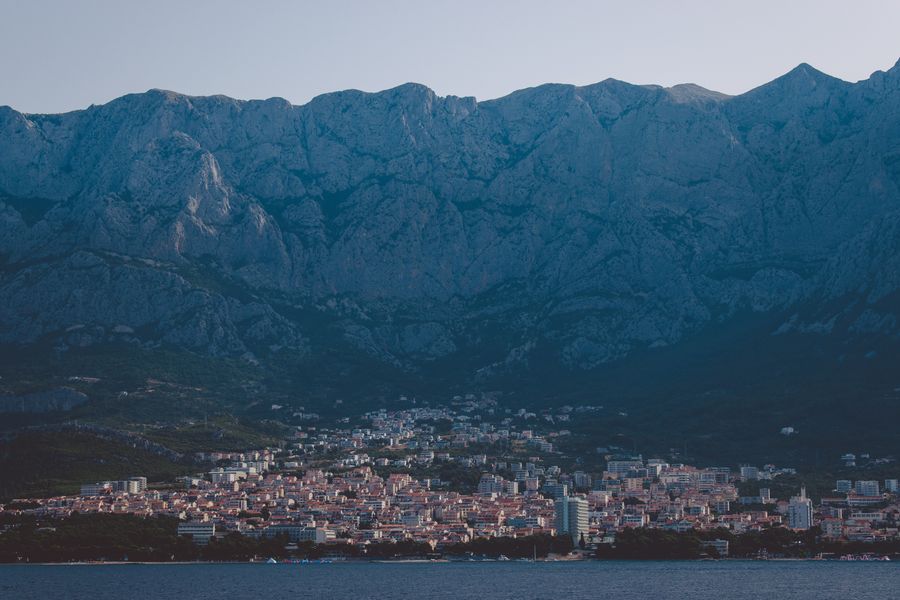
Hikes for ordinary walkers (Biokovo Skywalk, Velebit, Sljeme)
You do not need to be a climber to enjoy the Croatian mountains. We picked three walks by difficulty, from “drive up and stroll around” to a proper day in the hills.
Biokovo Skywalk and Sveti Jure — for anyone
If you want maximum payoff for minimum effort, head for Biokovo. A toll mountain road climbs to Sveti Jure, and on the way up sits the Biokovo Skywalk — a glass viewing platform at 1,228 metres from which you look straight down onto the Makarska Riviera and the sea. Entry to the nature park costs €10 in the shoulder season (April–May and October) and €15 in high season (June–September); children under 7 go free, and members of mountaineering clubs and cyclists pay €7 or €10 respectively. You can spend a maximum of 10 minutes on the glass platform, and 30 people are let on at a time.
💡 Tip: Set off for Biokovo as soon as the gate opens in the morning. The road is narrow with one-way restrictions, and by midday there is a queue for the Skywalk. Mornings also bring clearer air and a better chance of spotting the Italian coast. Tours and tickets for Biokovo →
Velebit and the Premužić Trail — for the fit
Velebit is a paradise for multi-day treks. The classic is the Premužić Trail (Premužićeva staza), a brilliantly engineered stone path roughly 57 km long that runs along the ridge of northern Velebit; it carries you comfortably through the roughest karst with the sea on one side and wilderness on the other. To climb the highest point, Vaganski vrh (1,757 m), base yourself at Paklenica National Park above Starigrad. Expect a long day, your own water and proper boots.
Sljeme above Zagreb — the easiest
When you want no logistics at all, ride up to Sljeme (1,033 m) above Zagreb. There is a cable car and a wide choice of marked trails of every length, so you can tailor the outing — from a half-hour stroll to a full-day loop. A perfect warm-up on your first day in the country, or a family outing with kids.
Climbing Dinara step by step
Croatia’s highest mountain is climbed from one sensible trailhead, and it pays to know the numbers in advance, because this is a long walk with no shade.
- Start: the hamlet of Glavaš by the mountain shelter, at roughly 560 metres (sources give 559 to 570 m), close to the source of the river Cetina.
- Distance and ascent: roughly 15.5 to 16.5 kilometres round trip to the Sinjal summit at 1,831 metres. The ascent is quoted either as 1,270 metres (the plain difference between trailhead and summit) or 1,350 metres (the sum of all climbing, including the undulating ridge) — both are correct, they are simply counted differently.
- Time: allow seven hours in total.
- Difficulty: physically demanding, technically easy. No protection or climbing experience needed, just fitness.
- Water: there is a well right by the shelter at the start. The Gornji Glavaš spring at around a thousand metres often dries up by late summer, so carry all your water.
- Descent: either the same way, or the more westerly variant past the Drago Grubać shelter.
- On the summit stand a red shelter box and a summit cross.
When to go: spring or early summer. In July and August the route has no shade and the midday heat makes it unwalkable. On the way it is worth stopping at the source of the Cetina, one of the most photogenic spots in the whole area.
When and how to visit the Croatian mountains
Spring and autumn are best — specifically May, June, then September and October. In these months the summits are pleasant, visibility is long and walking on karst is far easier than in the heat. We genuinely do not recommend July and August for a full-day hike on the bare southern mountains (Biokovo, Dinara, Velebit) — white limestone with no shade is an oven, and overheating and dehydration are real risks. The forested northern mountains (Risnjak, Snježnik) handle summer much better. In winter snow lingers mainly in the north and on Medvednica, where there is even skiing.
How to get there: most visitors fly into Split, Zadar or Zagreb and pick up a rental car. Split is the gateway to the southern mountains (Biokovo, Mosor, Dinara), Zadar to Velebit via Starigrad-Paklenica, and Rijeka to Risnjak and Učka; Zagreb airport sits an hour from the Sljeme cable car. A car is effectively essential at most trailheads — public transport into the mountains is poor. As a base for mountain days, Makarska works brilliantly (directly below Biokovo).
💡 Tip: Croatian karst means almost no water and no shade. Carry at least 2 litres of water per person, a hat, sunscreen and solid boots with soles that can take sharp rock. Sandals on the ridge are genuinely a bad idea. Look for accommodation with parking in Makarska here: accommodation in Makarska →
Where to next
- Trogir: 15 Things to Do in Croatia’s UNESCO Old Town
- Cape Kamenjak: 18 Things to See on Istria’s Southern Tip
- The Highest Mountains in Slovakia: 17 Peaks
- The Highest Mountains in the Czech Republic: Top 15 Peaks
Frequently asked questions
What is the highest mountain in Croatia? The highest mountain in Croatia is Dinara, whose summit Sinjal reaches 1,831 metres above sea level. It sits on the border with Bosnia and Herzegovina above the town of Sinj, and since 2021 it has been protected as a national park.
How many mountains over 1,500 metres does Croatia have? Roughly eight ranges have a summit above 1,500 m: Dinara (1,831 m), Biokovo/Sveti Jure (1,762 m), Velebit/Vaganski vrh (1,757 m), Plješevica/Ozeblin (1,657 m), Velika Kapela/Bjelolasica (1,533 m), Risnjak (1,528 m), Svilaja/Bat (1,508 m) and Snježnik (1,506 m).
Which Croatian mountain has the best sea view? Biokovo, without question (Sveti Jure, 1,762 m) above the Makarska Riviera — the cliff drops straight into the Adriatic and you look across the sea to Brač and Hvar, and on a clear day towards Italy. Velebit, Učka and Mosor above Split also offer superb sea views.
Are the Croatian mountains part of the Dinaric Alps? Yes, the overwhelming majority of Croatia’s high mountains belong to the Dinaric Alps (the Dinaric karst) — a limestone range running along the coast from Istria to Dalmatia and on into Bosnia and Montenegro.
Can you drive up Croatia’s highest mountains? Some of them, yes. A toll mountain road climbs Biokovo (Sveti Jure) almost to the summit, another goes up Istria’s Učka (Vojak), and a cable car runs to Sljeme above Zagreb. Dinara, Velebit and Plješevica, however, require a proper walk.
When is the best time to hike in the Croatian mountains? Spring (May–June) and autumn (September–October) are best, when temperatures are pleasant and visibility is good. In July and August the bare southern mountains get extremely hot with no shade — we do not recommend full-day hikes there in summer.
How much does entry to Biokovo and the Skywalk cost? Entry to Biokovo Nature Park costs €10 in the shoulder season (April–May and October) and €15 in high season (June–September). Children under 7 enter free, and mountaineering club members and cyclists pay €7 or €10. The Skywalk is included in the ticket.
Are the Croatian mountains demanding in terms of water and gear? Yes. This is karst, with essentially no springs and no shade. Take at least 2 litres of water per person, a hat, sunscreen and above all solid boots — sharp limestone destroys sandals and cheap footwear fast.
Which Croatian mountain is best with children? Sljeme above Zagreb (1,033 m) thanks to the cable car and short trails, Istria’s Učka (Vojak), which you can drive up, and the Biokovo Skywalk, where children under 7 enter free. None of them involves a hard climb.
Which airport is closest to the Croatian mountains? Split is the handiest for Biokovo, Mosor and Dinara; Zadar for Velebit and Paklenica; Rijeka or Pula for Učka and Risnjak; and Zagreb for Sljeme, about an hour from the cable car. Rent a car at the airport — the trailheads are hard to reach otherwise.
How high is Velebit and where is its highest summit? Velebit is Croatia’s longest range and its highest summit, Vaganski vrh, reaches 1,757 metres. It lies in southern Velebit above Paklenica National Park, with the slightly lower Sveto Brdo (1,753 m) right beside it.
Potřebujete pomoct s cestováním?
-
Ubytování 🏨
Vyberte si to nejlepší ubytování, ať už jste kdekoliv, přes Booking.com. -
Půjčení auta 🚗
Auto si snadno najdete přes Booking.com, kde máte často slevu díky ubytování, nebo Rentalcars.com, kde porovnáte nabídky většiny půjčoven. -
Zážitky 🎟️
Přes GetYourGuide.com si vyberete z nejrůznějších výletů i zážitků po celém světě, navíc se zrušením zdarma do 24 h předem.