
Last updated 1.9.2026
The Malá Fatra ridge hike is the finest two-day walk in the Carpathians that almost nobody outside central Europe has heard of. It follows a single red waymarked trail across the grassy summits of the Krivánska Malá Fatra in northern Slovakia, stays above the treeline for hours at a time, and between Chleb and Veľký Rozsutec it gives you a view over half the country for the price of a cheap flight and a train ticket. It is not a stroll, though. The full ridge is roughly 35 km with more than 3,000 m of ascent.
Below you will find exactly where the route runs, three versions of the Mala Fatra ridge hike depending on how many days you have, the spring trail closure that catches out most foreign visitors, where you can and cannot sleep up there, where the water is, how to reach the start and get home from the finish without a car, and what the ridge turns into in winter.
The Malá Fatra ridge hike at a glance
- The route: the red waymarked trail from Nezbudská Lúčka (opposite the village of Strečno) to Zázrivá, over Suchý, both Kriváň summits, Chleb, Steny, Stoh, the Medziholie saddle and Veľký Rozsutec.
- Full traverse: around 35 km, some 3,070 m of ascent, over 15 hours of walking time. Sensibly done in two or three days.
- Short version: take the cable car from Vrátna up to the Snilovské sedlo saddle and walk the ridge down to Štefanová — roughly 14 km in 6 to 7 hours.
- Sleeping: Chata pod Chlebom (1,423 m) and Chata pod Suchým (1,075 m). Wild bivouacking is banned; tents are allowed only within 100 m of a hut.
- Highest point: Veľký Kriváň, 1,709 m.
- Crucial for visitors: from 1 March to 15 June the Medziholie – Veľký Rozsutec – Medzirozsutce section is closed, which cuts the finale off the ridge hike.
- Getting there: train from Žilina to the Nezbudská Lúčka-Strečno halt; bus back from Štefanová to Žilina. No car needed.
- Cable car: Vrátna – Snilovské sedlo, €25 return (about £21) for an adult.
Read this first: the spring closure from 1 March to 15 June
Slovak national parks close selected paths every spring to protect wildlife during the breeding and calving season, and in the Malá Fatra one of those paths is the last and best act of the whole ridge. From 1 March to 15 June the section Medziholie – Veľký Rozsutec – Medzirozsutce is shut, along with two feeder trails:
- Medziholie – Veľký Rozsutec – Medzirozsutce (red waymarks) — the finale of the ridge hike
- Obšívanka – Malé nocľahy (blue waymarks)
- Vendovka – Malý Kriváň (blue waymarks)
In practice that means one thing. If you arrive before 15 June, you cannot finish the traverse over Veľký Rozsutec. You walk the ridge as far as the Medziholie saddle (1,185 m) and then drop down to Štefanová or Zázrivá. It is still a superb walk — the Chleb to Stoh section is the best part anyway — but plan for it rather than discovering it on a sign in the middle of nowhere, in Slovak, with a nine-hour day behind you.
The main red ridge trail itself is open all year, and the closure does not affect the Jánošíkove diery gorges or Malý Rozsutec, which are the two other things most visitors come for. If Veľký Rozsutec is the whole reason you booked the trip, aim for the second half of June at the earliest. Late June to early October is the sweet spot for the ridge in any case.
💡 Tip: Closure dates are set by the national park administration and can shift slightly from year to year. The current list is posted at the trailheads and on the park’s website, and the Terchová and Štefanová tourist information offices will confirm it in English.
What the Malá Fatra ridge hike actually is
The Malá Fatra (“Lesser Fatra”) is a limestone and crystalline range in north-west Slovakia, an hour from the Polish and Czech borders, and it splits into two halves. The northern half is the Krivánska Malá Fatra, protected as a national park; the southern half is the Lúčanska Malá Fatra. When people talk about the Mala Fatra ridge hike, they nearly always mean the northern half, because that is where the open, grassy, treeless ridge is.
The line is simple: one red waymarked trail, traditionally walked from Nezbudská Lúčka (across the Váh river from Strečno) to Zázrivá. Along the way you climb and drop over the following summits and saddles:
- Starý hrad (an old castle ruin), Plešel (981 m) and the climb to Chata pod Suchým (1,075 m)
- Suchý (1,468 m), Stratenec (1,513 m), the Priehyb saddle
- Malý Kriváň (1,671 m), the Bublen saddle, Pekelník
- Veľký Kriváň (1,709 m), the highest point of the range
- Snilovské sedlo (1,524 m), the saddle served by the cable car from Vrátna
- Chleb (1,646 m), Hromové (1,636 m) and the narrow Steny section
- Poludňový grúň (1,460 m), the Stohové sedlo saddle, Stoh (1,607 m)
- the Medziholie saddle (1,185 m), Veľký Rozsutec (1,610 m) and the descent through Medzirozsutce to Štefanová or Zázrivá
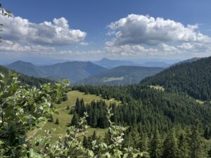
The stretch between Chleb and Stoh is what you will remember. The ridge narrows to a few metres, the ground falls away into deep valleys on both sides, and on Steny (the name means “the walls”) you walk along the edge itself. There are no chains or cables — this is not a via ferrata — but in the wet, and especially in cloud, it demands your attention.
How Slovak waymarking works
If you have only walked in the Alps or in Britain, the Slovak system will feel unfamiliar for about an hour and then obvious. It is the same scheme used across Czechia and Slovakia, maintained here by the Klub slovenských turistov (KST), the Slovak hiking club, and it is one of the best marked networks in Europe.
- Every waymark is a horizontal stripe of colour between two white stripes, painted on trees, rocks and posts. You will see one every few minutes; if you have gone ten minutes without one, you have left the path.
- Colour indicates the role of the trail, not the difficulty. Red is for main long-distance and ridge routes — the Malá Fatra ridge hike is red the whole way. Blue and green are connecting routes, typically the ways up from the valleys and the escape routes down. Yellow is for short links and shortcuts.
- Signposts give times, not distances. A post reading “Chleb 1:15” means an hour and a quarter of walking at an average pace. The times are honest and reasonably generous; with a heavy pack on the ridge, add a little.
- An arrow-shaped waymark means the path turns sharply. Off the main trails you may also meet marks for educational trails (white square with a green stripe).
Staying on the waymarked path is not just good practice here, it is the law. In a Slovak national park, walking off marked trails is an offence.
The Mala Fatra ridge hike: three versions depending on your time
Not everyone has three free days and a way of getting back to their luggage. These are the three sensible ways to walk the ridge.
1. One day, short version, using the cable car
The quickest way to get the best of the ridge into a single day. From Vrátna you ride the gondola up to Snilovské sedlo (top station 1,494 m), which saves you 750 m of climbing, then follow the red waymarks over Chleb, Steny, Poludňový grúň and Stoh to the Medziholie saddle and down to Štefanová.
- Distance: around 14 km by the map
- Ascent and descent: roughly 600 m up, 1,400 m down
- Time: 6 to 7 hours of walking
- Difficulty: moderate — the long descent is the hard part, not the climb
Adding the highest summit of the range is easy: from Snilovské sedlo, Veľký Kriváň is only another 185 m of ascent, so you may as well collect it.
💡 Tip: The cable car runs daily in summer from roughly 8.30 a.m. to 6 p.m., weather permitting. Take one of the first cabins. If a storm builds at two in the afternoon, there is nowhere on that ridge to hide.
2. Two days with a night in a mountain hut
Our pick, and the best ratio of effort to reward. On day one you climb to the ridge — either from Vrátna or from Šútovo — cross Veľký Kriváň and Chleb and sleep at Chata pod Chlebom. On day two you walk the finest section, over Steny and Stoh to Medziholie, and descend to Štefanová.
- Distance: roughly 23 to 25 km in total
- Ascent: around 1,500 m
- Time: 4 to 5 hours on day one, 6 to 7 hours on day two
- Difficulty: moderate to hard, mostly because of the second day
Starting from Šútovo is a nicer alternative to the cable car if you want to earn your height: from the Rieka roadside restaurant the path passes the Šútovský waterfall (38 m, the highest in the range) and the Mojžišove pramene springs, then climbs to Kopiská and the saddle behind Hromové.
3. The full Krivánska Malá Fatra traverse
The whole ridge, end to end: Nezbudská Lúčka over Suchý, both Kriváň summits, Chleb, Stoh and Rozsutec, finishing in Zázrivá.
- Distance: just under 35 km along the ridge
- Ascent: around 3,070 m
- Time: over 15 hours of walking — two brisk days, or three relaxed ones
- Difficulty: physically demanding, technically moderate
If that is not enough, you can carry on along the southern, Lúčanska half of the range to the Fačkovské sedlo saddle. The traverse of both halves of the Malá Fatra comes to 84 km with more than 5,800 m of ascent and is normally walked over four days. It also links into the E8 European long-distance path, which is how a fair number of foreign walkers end up here in the first place.
| Version | Distance | Ascent | Time | Difficulty |
|---|---|---|---|---|
| Short, with the cable car (Snilovské sedlo to Štefanová) | approx. 14 km | +600 / −1,400 m | 6–7 hrs, 1 day | moderate |
| Two days with a night in a hut | 23–25 km | approx. +1,500 m | 2 days | moderate to hard |
| Full Krivánska Malá Fatra traverse | approx. 35 km | approx. +3,070 m | 2–3 days | hard |
| Whole Malá Fatra (Zázrivá to Fačkovské sedlo) | 84 km | approx. +5,880 m | 4 days | very hard |
Which direction to walk, and why
Most people walk from Strečno towards Terchová, that is, south-west to north-east. The sun is behind you rather than in your eyes for most of the day, the notoriously long grind from Medziholie up to Stoh is a descent instead of a climb, and you finish in Štefanová or Terchová, where there are buses, beds, food and beer.
The other direction makes sense if you want Veľký Rozsutec on day one, while your legs are fresh and before the weather has a chance to turn. Be ready for a brutal start, though: it is a steep climb straight out of the valley.
💡 Tip: Avoid weekends if you possibly can. The stretch from Snilovské sedlo to Poludňový grúň is the busiest place in the whole range thanks to the cable car, and on a Saturday afternoon you will queue on the narrow bits.
Getting to the Malá Fatra from abroad
The good news for anyone flying in: this walk is entirely doable without a car, and the transport is cheap by western European standards.
Nearest airports
- Bratislava (BTS) — around 200 km. Direct trains to Žilina take roughly 2 hours 30 minutes and run at least hourly; the airport is connected to the main railway station by city bus.
- Vienna (VIE) — around 250 km and often the cheapest and best-connected option from the UK. Take the airport bus or train to Bratislava, then the train to Žilina. Allow four hours in total.
- Kraków (KRK) — around 200 km. Doable by bus and train via the border, but slower; a hire car makes more sense from here.
- Katowice (KTW) — around 180 km, popular with budget carriers, and there are direct coaches southwards towards Žilina.
- Ostrava (OSR) in Czechia — around 130 km and the closest of the lot, though the flight choice is thin.
By train to Žilina
Žilina is the hub for everything here. It sits on the main Bratislava–Košice line, so trains are frequent, cheap and reliable, and it is also served from Prague and Ostrava. From Žilina you are 25 to 30 minutes from the trailheads. Buy tickets on the ZSSK railway site or app; fast trains are worth reserving in summer, local trains never need it.
Do you need a car?
No, and for a point-to-point ridge walk a car is arguably a nuisance, because you finish 25 km from where you started. Public transport covers both ends of the route perfectly well. Hire a car only if you plan to combine the Malá Fatra with the Tatras or with more remote corners of Slovakia.
💡 Tip: Slovakia uses the euro and contactless payment is standard in towns — but mountain huts, small buses and village shops often are not. Draw out €50 to €100 in cash before you head up.
Getting to the start and back from the finish
The awkward part of any traverse is that it ends somewhere else. Here is how to solve it.
By train
From Žilina, local trains on the line towards Vrútky stop at Nezbudská Lúčka-Strečno, about ten minutes out. From Strečno a footbridge crosses the Váh river to the far bank, where the red waymarks begin. This is the classic start of the full traverse.
By bus
Suburban buses run by SAD Žilina go from Žilina to Terchová and on into the Vrátna valley, with stops at Terchová, Štefanová and Vrátna. This is your ride to the cable car at the start, and your ride home at the end. Buses are more frequent on weekdays than at weekends; check the last departure before you commit to a long day.
By car
The main headache is that you finish in a different valley from the one you started in. The simplest fix is to leave the car in Štefanová, travel to the start by bus and train in the morning, and walk back to it in the evening. Parking works out at roughly €3 a day (about £2.50). With two or three of you, a taxi to the start is worth the money.
Where to sleep on the ridge
There are two huts on the ridge itself and one just below it, and all of them are open year-round:
- Chata pod Chlebom (1,423 m) — the highest hut in the range, about 30 minutes from Snilovské sedlo along the blue waymarks. Since its 2021 refurbishment it has 48 beds; a bed with bedding costs €29 (about £24) plus a local tourist tax of €0.70. A reservation is only valid once the hut has confirmed it.
- Chata pod Suchým (1,075 m) — 62 fixed beds and 14 places in a communal dormitory. A bed with linen is €25 (about £21), a dormitory place with your own sleeping bag €20, and a shower runs on a €2 token.
- Chata na Grúni (973 m) — slightly below the ridge, an hour up from Štefanová. Bed and breakfast €30 (about £25), half board €37, and dogs are welcome.
How booking a Slovak mountain hut works
It is nothing like booking a hotel, and nothing like the reservation systems of the Alps either. Expect the following:
- You book by email or telephone, sometimes through a form on the hut’s own website. Some huts answer within hours, some within days.
- The booking counts only when the hut confirms it. Sending a request is not a reservation. Get the confirmation in writing and take a screenshot — there is no mobile signal on parts of the ridge.
- Basic English is usually fine, though a short, clear message with dates, number of people and type of bed works best. Slovak or Czech gets a faster reply.
- Bring cash in euros. Card terminals depend on a signal that comes and goes.
- Book weeks ahead for summer weekends. Chata pod Chlebom has 48 beds and fills up.
- Half board is normally available and worth taking — you are not carrying a stove up here.
Camping and bivouacking: the rules
Wild bivouacking on the ridge is not allowed. The national park’s visitor regulations permit camping and bivvying only within 100 metres of an existing hut. At Chata pod Chlebom pitching your own tent costs €10 a night including showers and toilets; at Chata na Grúni it is €2 per person. Enforcement is real, fines are real, and there is nowhere discreet to hide a tent on an open grass ridge anyway.
Before or after the walk, the most practical bases are Terchová and Štefanová. Find places to stay in Terchová →
Water and food on the route
This is the weak point of the whole walk. There is no water on the ridge itself. The springs lie in the saddles below the crest and you have to drop down to reach them: Príslop below Suchý, the Bublen saddle, the spring below Medziholie, and the one under the Medzirozsutce saddle. In a dry summer week they trickle rather than flow, and filling a 1.5-litre bottle can take five minutes.
Reliable water and hot food are at the huts, where an evening meal costs roughly €7 to €10. There is also a refreshment stand at Snilovské sedlo by the cable car station.
💡 Tip: Carry at least 2 litres per person per day, and 3 in hot weather. Always top up at a hut. Do not set off thinking you will “probably make it to the next spring”.
Malá Fatra weather and storms on an open ridge
The crest of the Krivánska Malá Fatra is grassy and almost entirely without shelter. From Chleb to Stoh there is nowhere to escape a thunderstorm and nowhere to escape the sun, and that is the single biggest safety issue on this walk.
- Start early. Summer storms here typically build in the afternoon. Aim to be off the ridge by three o’clock.
- The cloud is famous. It can be thick enough that you cannot see the next waymark from the last one. Download an offline map and start the day with a full battery.
- Wind and sun. It blows up there even in July, and with no shade you will burn faster than you expect. A windproof, a hat and high-factor sun cream belong in the pack every time.
- Season. Late June to early October is the reliable walking window. July and August are warmest and busiest; September usually brings the clearest air and the best views.
- Check the forecast for the summits, not the valley. Žilina at 350 m and Veľký Kriváň at 1,709 m routinely have different weather. Slovak mountain forecasts and the avalanche service (HZS) are the sources locals use, and there are webcams at the cable car and at Chata pod Chlebom.
What to pack
We walk in these hills often enough to have a fixed list. Nothing exotic on it, but nothing on it is optional either.
- Boots above the ankle with a decent sole, plus trekking poles — the descent from Stoh is long and steep
- 2 to 3 litres of water per person per day
- Waterproof jacket and a warm layer, even in August
- Head torch, first aid kit, high-factor sun cream
- Cash in euros; the huts do not always take cards
- Sleeping bag or a sheet liner, depending on the hut’s rules
- Offline map (mapy.com and Hiking.sk both cover Slovakia well) and a power bank
- The European emergency number is 112; Slovak mountain rescue (Horská záchranná služba) is on +421 18 300
The Malá Fatra ridge in winter
A winter traverse is a different sport altogether. The ridge is marked with tall poles, so you will not lose the line in poor visibility, but the ground above the treeline turns hard and icy.
- Crampons are mandatory — proper mountaineering crampons, not chain-type traction aids, which are useless here. An ice axe and the ability to self-arrest matter on the traverses.
- Avalanche risk is real. The Suchý to Malý Kriváň and Bublen section is not pole-marked in winter, is hard to navigate and crosses avalanche terrain. In poor visibility or at a raised avalanche grade, leave it alone.
- The days are short, and in winter the park additionally restricts movement to between 7 a.m. and 6 p.m.
- Snow can lie on the ridge from November into April, and conditions in March are often more wintry than the calendar suggests.
If it is your first winter outing on this ridge, do the short version from the cable car and see how you get on.
National park rules you need to know
Beyond the spring closure covered above, a few rules apply the whole year, and rangers do check:
- Marked trails only. Walking off the waymarked path is prohibited in the national park.
- Time restrictions. From 16 April to 31 October you may be on the trails between 6 a.m. and 9 p.m.; from 1 November to 15 April, between 7 a.m. and 6 p.m.
- Dogs on a lead, no exceptions.
- No wild camping or bivouacking away from the huts, and no open fires.
- Bears live here. The Malá Fatra has a healthy brown bear population. Make noise on wooded sections, never leave food outside a tent, and do not run if you meet one.
Common mistakes on the ridge
- Underestimating water. There is none on the crest, and the springs in the saddles barely run in a dry spell.
- Setting off late. An afternoon thunderstorm on Steny is the worst scenario this walk has to offer.
- Not booking the hut. Chata pod Chlebom has 48 beds and is full most summer weekends.
- Planning Rozsutec for May. The section over the summit is closed until 15 June.
- Leaving the car at the start. The traverse finishes somewhere else entirely. Sort out the return before you set off.
- Carrying too much. With huts on the route you need neither tent nor stove.
- Trusting the valley forecast. The summits make their own weather, and 1,700 m in the Carpathians is not 1,700 m in the Alps in terms of shelter — there is none.
Guided trips and day tours around Žilina can be booked through GetYourGuide →.
Where to go next
The Malá Fatra rewards more than one day. If the ridge has given you a taste for it, the obvious follow-ups are the Jánošíkove diery gorges above Štefanová, with their ladders and wooden walkways through a narrow limestone canyon; the ascent of Veľký Rozsutec, the pyramid-shaped peak that closes the ridge; its smaller neighbour Malý Rozsutec, shorter but seriously steep; and a general round-up of day walks across the range for anyone basing themselves in Terchová. It is worth reading up on how to behave in bear country before you come, and the Súľov Rocks, a conglomerate rock town half an hour west of Žilina, make an excellent recovery day when your legs have had enough of the ridge.
Malá Fatra ridge hike FAQ
How long is the Mala Fatra ridge hike?
The classic traverse of the Krivánska Malá Fatra from Nezbudská Lúčka to Zázrivá is just under 35 km with around 3,070 m of ascent. Pure walking time is over 15 hours, so it is normally split over two or three days. The short version using the cable car is about 14 km and takes 6 to 7 hours.
Is any part of the Mala Fatra ridge closed to walkers?
Yes. From 1 March to 15 June the section Medziholie – Veľký Rozsutec – Medzirozsutce is closed, as are the Obšívanka – Malé nocľahy and Vendovka – Malý Kriváň trails. That means you cannot finish the ridge hike over Veľký Rozsutec before mid-June. The main red ridge trail itself stays open all year, and the Jánošíkove diery gorges are not affected.
Where can you sleep on the Mala Fatra ridge?
There are two huts on the ridge: Chata pod Chlebom at 1,423 m, where a bed costs €29 (about £24), and Chata pod Suchým at 1,075 m, where a bed is €25 and a dormitory place €20. Both are open all year. Book by email or phone well ahead for summer weekends, and remember that a reservation only counts once the hut confirms it.
Can you wild camp or bivouac on the ridge?
Not freely. The national park’s visitor regulations allow tents and bivouacs only within 100 metres of an existing hut. Pitching your own tent at Chata pod Chlebom costs €10 a night including showers and toilets, and at Chata na Grúni €2 per person. Open fires are banned throughout the park.
How much does the Vrátna cable car cost and when does it run?
Under the price list valid from 1 May 2026, an adult return ticket to Snilovské sedlo is €25 (about £21), €22 for juniors and seniors and €20 for children aged 7 to 12, with a euro off if you book online. In summer it runs daily from roughly 8.30 a.m. to 6 p.m. depending on the weather, and the ride takes about 8 minutes.
Can you do the Mala Fatra ridge hike without a car?
Yes, and it is arguably easier without one, because the walk finishes in a different valley from the one it starts in. Take a train to Žilina — it is on the main Bratislava–Košice line, about 2 hours 30 minutes from Bratislava — then a local train to the Nezbudská Lúčka-Strečno halt for the start. At the end, SAD Žilina buses run from Štefanová and Terchová back to Žilina. The nearest airports are Vienna, Bratislava, Ostrava, Katowice and Kraków.
Is there water on the route?
Not on the ridge itself. The springs sit in the saddles below the crest — Príslop, Bublen, below Medziholie and below Medzirozsutce — and they run weakly in dry spells. Reliable water and hot food are at the huts. Plan on 2 to 3 litres per person per day.
What is the Mala Fatra ridge like in winter?
It is a full winter mountain route. The ridge is pole-marked so navigation is manageable, but the ground ices up and you need proper mountaineering crampons rather than traction aids, plus an ice axe. The Suchý to Malý Kriváň and Bublen section is not pole-marked, is hard to navigate and crosses avalanche terrain. In winter the park also restricts access to between 7 a.m. and 6 p.m.
Read next
Potřebujete pomoct s cestováním?
-
Ubytování 🏨
Vyberte si to nejlepší ubytování, ať už jste kdekoliv, přes Booking.com. -
Půjčení auta 🚗
Auto si snadno najdete přes Booking.com, kde máte často slevu díky ubytování, nebo Rentalcars.com, kde porovnáte nabídky většiny půjčoven. -
Zážitky 🎟️
Přes GetYourGuide.com si vyberete z nejrůznějších výletů i zážitků po celém světě, navíc se zrušením zdarma do 24 h předem.