Last updated 29.8.2026
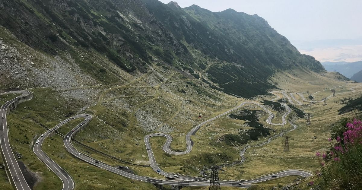
A road that climbs above two thousand metres in a stack of hairpins, cuts through the ridge of Romania’s highest mountains and drops on the other side to a lake hanging under the peaks. The Transfagarasan road was built out of fear of Soviet tanks, it cost the lives of dozens of workers, and today it is the best known stretch of tarmac in Eastern Europe. Below is the whole route, stop by stop, plus the one detail plenty of people miss and then drive all that way for nothing: the road is shut for most of the year.
In short: the Transfagarasan road
- The road is usually closed from the end of October to the end of June because of snow. It can also shut in summer when the weather turns.
- It was built between 1970 and 1974 on the orders of Nicolae Ceausescu, as a response to the Soviet invasion of Czechoslovakia in 1968.
- It is 151 kilometres long, the main mountain section runs for roughly 90 km and it climbs to 2,042 metres.
- It is Romania’s second highest paved road. Only the Transalpina goes higher.
- The Balea tunnel is 884 metres long, the longest road tunnel in Romania.
- Average speed is around 40 km/h. Ninety kilometres here means several hours, not one.
- Do not feed the bears. The Transfagarasan is exactly where the problem of bears habituated to human food started.
When is the Transfagarasan road open?
Start here, because this is the paragraph people skip and then arrive at a barrier. The Transfagarasan road is normally closed from the end of October to the end of June because of snow. That leaves it open for roughly four months a year. The exact opening date moves from year to year depending on when the snow melts in the highest sections, and it is announced by the Romanian roads authority rather than fixed in a calendar.
Two things follow from that. First, spring is not the season here. April and May look green in the valleys and are still deep in snow at 2,000 metres. Second, the road can close in the middle of summer too, whenever a storm, thick fog or a landslip makes the pass unsafe.
What closes is always the highest section over the pass. The lower stretches on both sides stay open all year, so you can still drive up the northern side as far as the cable car and ride it to Balea Lake in winter. What you cannot do out of season is cross the ridge by car.
The best time to drive it
July to mid September is the window where an open road is close to a certainty. July and August are also the busiest: coaches, motorcycle groups and queues for the viewpoint laybys. If you want the same reliability with fewer people, aim for the first half of September, when the weather is usually still settled and the crowds have thinned out.
Check the road status on the morning you drive it. The opening date differs every year and even in August the section over the pass occasionally closes for weather. The safest window is July to mid September, when it is open in all but exceptional years.
Why the Transfagarasan road exists
This was never a tourist project. It is a military road, built between 1970 and 1974 on the orders of Nicolae Ceausescu, and the reason was the Soviet invasion of Czechoslovakia in 1968. Ceausescu expected Romania might be next and wanted a route that would let the army move quickly across the mountains from one half of the country to the other, even if the main roads fell.
The price was steep. Around six million kilograms of dynamite went into the construction, and official records put the death toll at 40 soldiers. Unofficial estimates from the workers themselves talk about hundreds. The nickname that stuck is Ceausescu’s Folly.
What made it famous outside Romania came much later. Jeremy Clarkson called it the best road in the world on Top Gear in November 2009, and from that point on the Transfagarasan stopped being a way of getting somewhere and became the destination itself. In high summer the traffic shows it.
Getting to the Transfagarasan road
The road runs north to south across the Fagaras mountains, roughly in the middle of Romania, and the practical question is which end you want to arrive at.
- Sibiu (SBZ) is the closest airport to the northern end and the easiest choice if the road is the main reason for the trip. It is a small, quick airport in a town you will want an evening in anyway.
- Bucharest (OTP) is the biggest hub with the widest choice of flights and the cheapest car hire, and it sits south of the mountains, so you approach the road from the Curtea de Arges side.
- Cluj-Napoca (CLJ) works if you are combining the Transfagarasan with northern Transylvania and Maramures. It is further away, so give yourself a driving day either side.
Seasonal routes to all three change from year to year, so check current schedules rather than assuming a direct flight exists. Timing matters more than the airport: there is no point flying in for a long weekend in May.
Hiring a car
You need your own vehicle. There is no bus over the pass, and the whole appeal of the road is being able to stop where you like. A few things worth knowing before you book:
- Book an automatic well ahead if you do not drive manual. Most of the Romanian fleet is manual and automatics sell out in high season.
- The smallest car is often the best car here. The hairpins are tight and the laybys are small. Nothing about this road rewards a large vehicle.
- Check the vignette. Romanian motorways and national roads need a rovinieta, and hire cars usually come with one. Confirm it rather than assume it.
- Carry cash in lei (RON). Stalls, small guesthouses and parking attendants often will not take cards, and nobody is interested in euros or pounds. At the time of writing a pound is worth roughly six lei, but check the rate before you travel.
Do not plan the drive as a transfer between two hotels. The Transfagarasan works as its own day: sleep at one end, drive it slowly, sleep at the other. Squeezing it in between an early check-out and a late check-in is how people end up doing the best part of it in the dark.
Driving the Transfagarasan road, stop by stop
You can start either from the south at Curtea de Arges or from the north at Sibiu. Both work, but from the south you drive towards the hairpins and see them stacked up in front of you, which is the more dramatic way round.
1. The Vidraru dam and lake
The southern approach follows a big reservoir squeezed between mountains. You can drive across the dam wall and look straight down the valley from it. Above the dam stands a statue of Prometheus, which is easy to miss if you are watching the road.
2. Poenari Castle
A ruin on a rock spur above the road, and the castle Vlad the Impaler actually lived in, unlike the far more famous Bran. Getting up there means a staircase of more than 1,400 steps and about half an hour of climbing. Check in advance whether it is open, because it closes from time to time when bears are around.
3. The southern hairpins
The most photographed stretch of the whole road. There are viewing laybys right at the bends, and from them you look down on the ribbon of tarmac folding back on itself below you. In season they fill up, and parking is harder to find than you would expect from the photographs.
4. Balea Lake
A glacial lake sitting directly under the pass, at the highest point of the route. There is a chalet, a cluster of food stalls and, in winter, an ice hotel built fresh each year. This is also the spot you can reach by cable car when the road itself is closed.
5. The Balea tunnel
The high point of the crossing and, at 884 metres, the longest road tunnel in Romania. It is unventilated, narrow and unlit along its full length, so take it slowly and with your headlights on.
6. The Balea waterfall
On the northern side below the pass, a short walk from the car park. The cable car up to the lake runs from beside it.
7. The descent to Sibiu
The northern side is gentler and runs down through forest and villages into the foothills. The monastery at Cartisoara is worth the stop, and the fortified Saxon churches scattered around the area are the reason to keep driving slowly once the mountains are behind you.
How long does the Transfagarasan take?
The most common mistake is treating the crossing as a transfer between two towns. Average speed on the road is around 40 km/h, and on top of that come the stops, the photographs and, in season, the queues.
- The crossing itself, meaning the main mountain section, takes roughly three hours without stopping.
- With normal stops, set aside a full day.
- With Poenari and a walk at the lake it becomes a long day, and one that works far better with a bed booked at each end.
Two more things stretch the day out. Mornings are usually clearer than afternoons up at the pass, so an early start buys you the views. And the light on the southern hairpins is best when the sun is still high, which is another argument for not leaving the climb until late afternoon.
What the driving is actually like
- The road is narrow and full of blind bends. Do not overtake where you cannot see.
- There are a lot of motorcyclists and they move quickly. Bear that in mind when pulling out of a layby.
- The weather changes in minutes. Sunshine at the bottom, fog and eight degrees at the pass.
- Fill up in the foothills. There is no petrol station on the mountain section.
- Phone signal drops out in places. Download your maps for offline use.
- Leave campervans and large motorhomes behind. The hairpins are at the limit for them and in some spots there is nowhere to turn around.
None of this makes the road dangerous in itself. It is a well surfaced mountain road driven by ordinary hire cars every summer day. What catches people out is treating it like a motorway with a view: braking late into a blind bend, overtaking a slow coach on a straight that turns out not to be one, or coming down the northern side riding the brakes until they fade. Use a low gear on the descent and the road looks after itself.
Do not feed the bears and do not stop for them. Bears appear beside this road precisely because they have learnt that people hand out food, and it is a problem tourists created. Feeding a bear is dangerous for you and a death sentence for the animal, because a bear that loses its wariness of humans sooner or later ends up in a conflict it does not survive. If you see one, stay in the car and keep going.
What to sort out before you set off
The Transfagarasan is not an ordinary road, and a good half of the trouble people run into up there can be dealt with in the half hour before departure:
- A full tank. There is no petrol station on the mountain section, the nearest ones are down in the foothills at either end. Fill up before the climb, not when the warning light comes on.
- A car in good order. Brakes above all. The engine works hard on the way up, the brakes take the punishment on the long, steep descent.
- Food and water for the day. There are stalls at Balea Lake and a couple of the viewpoints, but in peak season there is a queue, and out of season they may not be open at all.
- A charged phone and a power bank. Signal fails on parts of the route, so download your maps offline before you leave.
- Warm clothes. It can be thirty degrees at the bottom and ten with a wind at the pass.
- Cash in lei for the stalls and parking.
Where to eat and what to do besides driving
There are few restaurants on the route and they cluster in two places: at Balea Lake, where the chalet has a dining room and there are stalls outside, and down in the foothills at both ends, where you find ordinary Romanian places at ordinary prices. In between there is essentially nothing, so plan lunch rather than hoping for it.
If you do not want to spend the whole day behind the wheel, you have options:
- Walks from Balea Lake. Marked paths lead from the lake up onto the Fagaras ridge, and it is the easiest way to get out of the car and into real mountains. Wear proper boots and accept that the weather up there can turn within the hour.
- The climb up Moldoveanu, Romania’s highest peak, for anyone with a few days and multi-day mountain experience behind them.
- The cable car to the lake from the northern side, which runs even when the road over the pass does not.
- Swimming and rafting on Lake Vidraru and in the Arges valley on the southern side.
- The climb to Poenari as an antidote to a day of sitting down.
Transfagarasan or Transalpina?
Romania has two famous mountain roads and the question of which one to drive comes up constantly:
- The Transfagarasan is the better known and the more dramatic, and it has more to stop for: the lake, the tunnel, the castle, the waterfall. It also has considerably more people on it.
- The Transalpina is Romania’s highest paved road, so it goes higher still, but the landscape is more open and less theatrical. It is quiet.
If you only have time for one, drive the Transfagarasan. If you have two days, do both. They are not far apart and they are not really competing: one is a canyon of rock and hairpins, the other is a long ridge with sheep on it.
Where to stay
- Sibiu on the northern side, the best base of the two, with a beautiful old centre to come back to.
- Curtea de Arges on the southern side, close to Poenari.
- The chalet at Balea Lake right at the top, if you want to see the lake in the morning before anyone else arrives. Book a long way ahead.
- Guesthouses in the Fagaras foothills, which double as a base for walking.
You can compare places near the Transfagarasan on one map with Stay22.
What to add to the trip
- The Fagaras mountains with Moldoveanu, Romania’s highest peak at 2,544 metres.
- Sibiu and the fortified Saxon churches around it.
- Brasov, Bran and Rasnov to the east.
- The Transalpina as a second mountain road.
- Sighisoara, the fortified UNESCO listed town.
Transfagarasan road: frequently asked questions
When is the Transfagarasan road open?Roughly from the end of June to the end of October. For the rest of the year the highest section over the pass is closed because of snow, and it can also shut in the middle of summer when a storm or fog rolls in. The safest window is July to mid September, and you should check the road status on the day you drive.
Is the Transfagarasan open today?There is no single date that answers this. The opening is announced each year by the Romanian roads authority once the snow has cleared from the top, and the pass can be closed again at short notice for weather. Check on the morning of your drive, and if you are travelling in June or October, have a plan B that does not involve crossing the ridge.
How long is the Transfagarasan and how high does it go?151 kilometres in total, of which the main mountain section is around 90 kilometres, climbing to 2,042 metres above sea level. It is the second highest paved road in Romania, beaten only by the Transalpina. The tunnel under the pass at Balea Lake is 884 metres long, the longest road tunnel in the country, and it is unlit, so drive it slowly with your headlights on.
How long does it take to drive the Transfagarasan?The mountain section alone takes about three hours without stopping, because average speed works out at around 40 km/h. Add stops at the lake and the hairpins and a climb up to Poenari, and it is a full day.
Is the Transfagarasan dangerous?Not if you drive sensibly. The road is narrow, full of blind bends and busy with fast motorcyclists. The weather changes in minutes, and on the mountain section there is no petrol station and no reliable phone signal. Leave campervans and large motorhomes at home.
What is Balea Lake?A glacial lake directly below the pass at the highest part of the route, with a chalet beside it and an ice hotel rebuilt there every winter. You can reach it by cable car from the northern side even when the road over the pass is shut, which makes it the one part of the Transfagarasan that is genuinely open all year.
Are there bears on the Transfagarasan road?Yes. Bears turn up beside the road, and it is a problem created by tourists feeding them. Never feed a bear and never stop for one. It is dangerous for you and it ends in death for the bear, because an animal that loses its fear of people eventually comes into conflict with them.
Which direction is best to drive the Transfagarasan?South to north, from Curtea de Arges towards Sibiu. You pass the Vidraru dam and Poenari Castle first, then the long climb, and you finish by driving the famous hairpins with the whole stack of them in view ahead of you. Driving north to south gives you better photographs of the hairpins, because you climb them and look back down. Most tours and hire companies suggest the southern approach for the smoother run.
Can you do the Transfagarasan without a car?There is no scheduled bus over the pass. Buses get you as far as the foothills at best, to Cartisoara in the north and Curtea de Arges in the south. To reach Balea Lake you take the cable car from Balea Cascada, which runs year round and is the only reliable car-free option. Otherwise it is an organised day trip from Sibiu or Brasov, or a taxi for the day.
Transfagarasan or Transalpina?The Transfagarasan is better known, more dramatic and has more to stop for, but there are considerably more people on it. The Transalpina goes higher, is more open and much quieter. If you only have time for one, drive the Transfagarasan. They sit close together and do not really compete.
Potřebujete pomoct s cestováním?
-
Ubytování 🏨
Vyberte si to nejlepší ubytování, ať už jste kdekoliv, přes Booking.com. -
Půjčení auta 🚗
Auto si snadno najdete přes Booking.com, kde máte často slevu díky ubytování, nebo Rentalcars.com, kde porovnáte nabídky většiny půjčoven. -
Zážitky 🎟️
Přes GetYourGuide.com si vyberete z nejrůznějších výletů i zážitků po celém světě, navíc se zrušením zdarma do 24 h předem.